Colin Quilter
In mid-March 2021 nine of us went to Aotea (Great Barrier Island) for five days. The trip was intended to be less of a conventional cycle tour, and more of a camping, walking and swimming holiday using bikes to get around. I hope the notes which follow will help others planning a similar trip.


Aotea. A rugged island about 70km long by 35km wide. The west coast is rocky, bush-clad and indented with sheltered harbours; the east coast is comprised of long, white-sand surf beaches separated by rocky headlands. There is no reticulated electricity or water, so residents use solar power or generators, and tank water. Stepping ashore on Aotea is very like arriving on Stewart Island; what’s not to like?
Our route. An anticlockwise circuit. Day 1 Tryphena to Harataonga, then on Day 2 to Akapoua Bay near Port Fitzroy, then on Day 3 to Whangaparapara Harbour, then on Day 4 to Medlands Beach, and finally on Day 5 back to Tryphena.
Getting there. We travelled on the SeaLink ferry which takes about 4 hours to reach Tryphena from the Hamer St terminal in Auckland. The trip is expensive: a return fare including a bike cost about $220 per person, (a bit more for those not eligible for the Senior discount). However the expense of getting there probably limits the number of visitors (and cars) to the island, which is a good thing.
Stores. At Tryphena and Port Fitzroy, plus a smaller one at Claris. There are two cafes (which may be closed at off-peak times) at Tryphena and Claris.

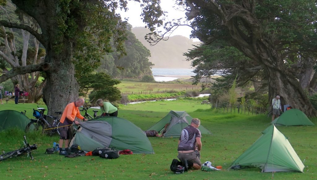
Campgrounds. We used DOC campgrounds which are excellent and sited close to some of the best beaches on the island. All have toilets, fresh water, and a cooking shelter. We stayed at the following, (in this order):
- Harataonga Bay. A large, shady site on the east coast, 10 min walk from the beach. In my opinion, the best campground on Aotea; but there’s a big climb from Awana and a corresponding descent to reach it.
- Akapoua Bay. An inlet just south of Port Fitroy. Plenty of shade and birdlife. A walking track to the top of Mt Hobson starts just south of here, and so does the Forest Road.
- The Green in Whangaparapara Harbour. A beautiful sheltered campsite, small but with plenty of shade. No road access, just a path suitable for walkers and cyclists.
- Medlands Beach. The campground is at the southern end of this surf beach. It is shady but can be exposed to a westerly wind which comes down off the hills behind the bay. There’s a walk/scramble up onto the southern headland of the beach, and spectacular views from the pinnacle on top.
The two DOC campsites we did not stay at are:
- Awana Beach. A grassy site at the western end of this surf beach; but very exposed to both wind and sun.
- Whangapoua. Another exposed site on the shore of the Whangapoua estuary, near the Okiwi Airfield.
Roads. The road linking Tryphena and Port Fitzroy is sealed. Most other roads are not. We found the unsealed roads to be in excellent condition because they were almost without gravel, so the two ruts were worn smooth.
Hills. Let me say that again: HILLS. Here are the main ones:
- Between Tryphena and Medlands 198m gain in elevation
- Between Claris and Awana Beach 117m
- Between Awana Beach and Okiwi 350m. The turn-off to Harataonga occurs about a third of the way up this hill, and from there you drop back down to sea-level at the beach. Next morning, if heading north, you climb back out of the bay and up to the summit at 350m.
- Between Okiwi and Port Fitzroy 209m
- Between Whangaparapara Harbour and Claris 145m
- Forest Road, heading south 432m total gain in elevation

The Forest Road. This is a 4WD road heading south through the bush from Port Fitzroy to Whangaparapara. DOC describes it as a mountain-bike track. We were not sure whether it would be feasible for touring bikes carrying panniers, but Steve found a reliable source (two men drinking beer at the Port Fitzroy store) who convinced him that it would “go”. So we went.
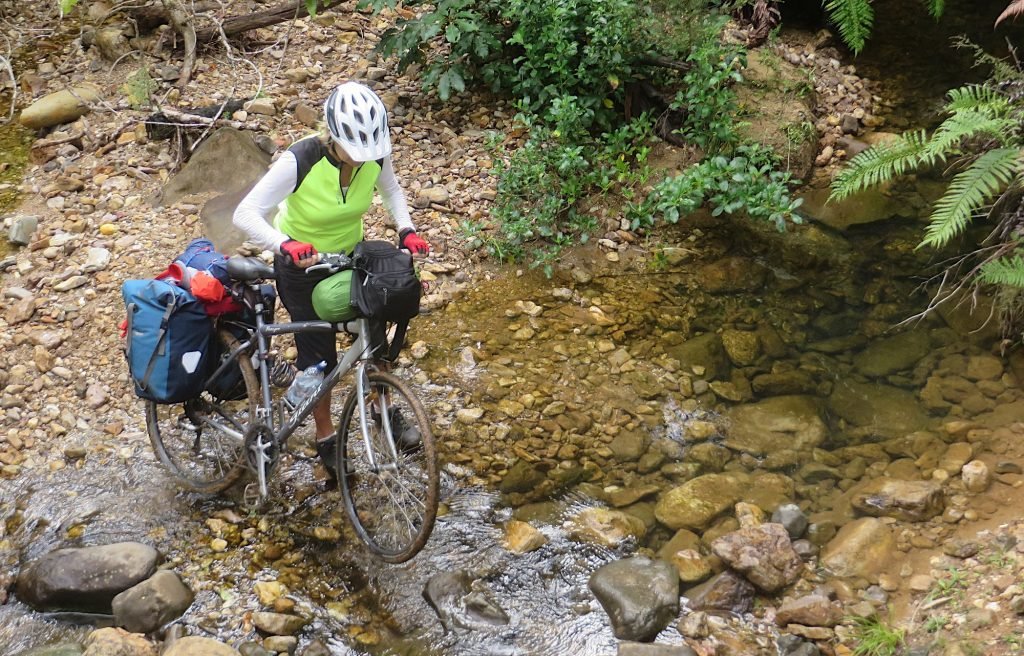
The road runs at right angles across several ridges and valleys which form the western slopes of Mt Hobson. The road climbs steeply to a ridge, then it plunges down into the next stream, then it climbs, then it descends, and so on. And on. We pushed our bikes up most of the ascents.The road surface was often bare clay, which was slippery after recent rain, and it was difficult to get traction while pushing the loaded bikes uphill. Even that legendary hill-climber John Billinge was forced to admit that this was steep country. We averaged about 6km/hr and took most of the morning to cover 13km. (This road would be much easier after dry weather, and on mountain bikes empty of camping gear).
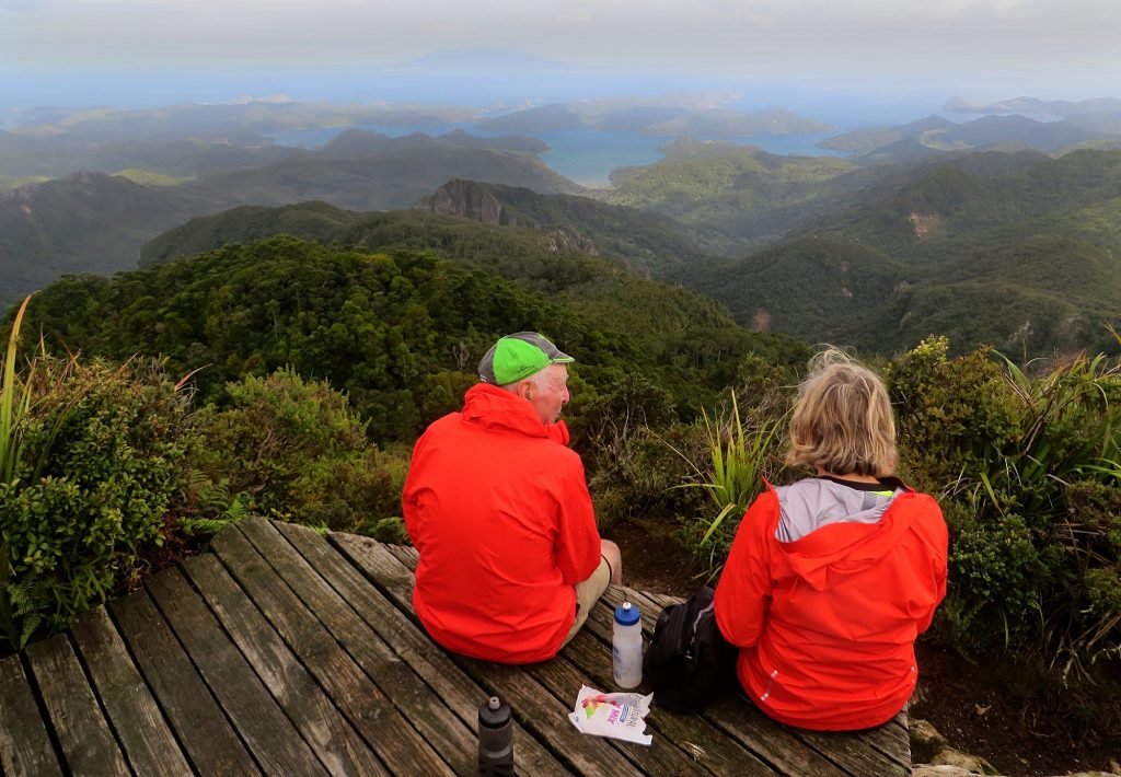
The walks. Climbing to the summit of Mt Hobson (Hirakimata) is obligatory. We used the Windy Canyon track which is on the eastern side of the mountain and starts at the high point of the road between Awana and Okiwi. The track from the other side (west coast) leaves Port Fitzroy, follows the Kaiaraara Stream, then climbs steeply past the remains of two kauri dams. The wet (and often cloudy) upper slopes are home to black petrels which nest in burrows there, so DOC has built extensive flights of wooden steps to prevent the feet of travellers from crushing the burrows. The view from the top includes all of the outer islands of the Hauraki Gulf. You may need to sit down to enjoy it, because it can be very windy up there.
In summary: Aotea is a great cycling destination if you adjust your expectations to numerous hills and short distances, and include the walking and swimming which are necessary to gain the most from the island. We cycled just 100km in total during the five days, which must be some sort of record for an ACTA tour, but nobody complained that our daily runs were insufficient. We left several places unexplored, so there are incentives for another trip in future.